Warning: mysql_fetch_array() expects parameter 1 to be resource, boolean given in C:\xampp\htdocs\www\include\functions.php on line 9

Warning: Invalid argument supplied for foreach() in C:\xampp\htdocs\www\include\functions.php on line 11

Warning: mysql_fetch_array() expects parameter 1 to be resource, boolean given in C:\xampp\htdocs\www\include\functions.php on line 130
 
 
SOFTWARES > TRIMBLE > LAND
Trimble eCognition
The most powerful solution for analysis & extraction
Trimble eCognition software is a powerful solution for the analysis and extraction of information from geospatial data collected via aerial, satellite and mobile mapping platforms. This new release simplifies and reduces the time taken to classify objects in imagery data sets using the new template matching function. With eCognition 9, users can define objects graphically to streamline the template creation process. These templates are used to automatically identify objects of interest in imagery. 
 
In addition, remote sensing and Geographic Information System (GIS) professionals can now integrate data layers more efficiently through improved GIS tools within eCognition 9. These capabilities provide a framework for advanced analysis that allows professionals to use eCognition to resolve a larger range of geospatial queries and obtain more accurate results.
 
"With the fast growth of imaging and remote sensing data collection, geospatial professionals need faster and simpler methods to analyze and extract meaningful information from the data," said Alain Samaha, business area director of Trimble's Geospatial Software Solutions Division. "eCognition 9 takes simplification and integration to a new level while augmenting the precision and accuracy of results. This opens the door to a wider range of applications across multiple industries."
 
Datasheet
GPS analysist
GPS analysist
Streamlined GNSS data processing inside Esri ArcGIS 
Take a giant leap forward in productivity and improve your data quality with Trimble® GPS Analyst™ extension for Esri ArcGIS for Desktop software. Trimble GPS Analyst extension optimizes your field-to-office workflow by allowing you to work directly with GNSS data inside your personal geodatabase. And because the extension comes with a package of powerful GNSS postprocessing tools, incorporating Trimble DeltaPhase™ differential correction technology, you can be sure you have GNSS data that is consistent, reliable, and accurate.
 
Let Trimble GPS Analyst extension for Esri ArcGIS for Desktop improve your data accuracy and your field-to-office workflow by making GNSS data an integral part of your GIS. A customizable extension that allows you to work directly with GNSS data directly inside the Esri ArcGIS for Desktop software, Trimble GPS Analyst extension is the ideal platform for industries from utilities to resource management to government organizations and more.
Trimble GPS Analyst extension is perfect for Esri ArcGIS software customers that:
Use Esri ArcPad and Trimble GPScorrect™ extension for Esri ArcPad software or Trimble TerraSync™ software as their field application
Use notebook or tablet applications in the field
Develop custom office or field applications
To discuss how Trimble GPS Analyst extension for Esri ArcGIS for Desktop software can streamline your GPS data processing contact your local Trimble reseller.
Datasheet
Trimble GPS Pathfinder Office
Powerful and easy to use GNSS data processing
Features
  • Differential corrections to improve the quality of GNSS data collected in the field
  • H-Star data processing for high accuracy and support for GLONASS postprocessing
  • Data import and export in a variety of GIS and CAD formats
  • Sophisticated data dictionary editor to ensure consistency between the field and the office
  • Quality control of GNSS data before exporting to GIS


Datasheet
Trimble TerraSync
Field-proven software with powerful functionality for productive GIS data collection and maintenance.
Software for highly productive field GIS data collection and maintenance
Trimble® TerraSync™ software is designed for fast and efficient field GIS data collection and maintenance.
Integrating all the ways you collect data—with a GNSS handheld computer, laser rangefinder, or centimeter-grade equipment—it's a powerful system for the collection of high quality feature and position data for GIS update and maintenance.
 
Features
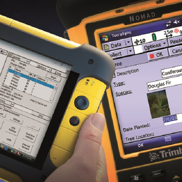
  • Software designed for efficient field GIS data collection and maintenance 
  • QuickPoint data collection mode for easy productive one-click data capture 
  • Optimized for Trimble handhelds with integrated digital cameras 
  • Support for centimeter-grade RTK receivers 
  • Conditional attributes for dynamically adapting data capture forms 
  • Customizable user interface simplifies field operation 
  • Smart data maintenance 
  • Seamless GNSS control in the field for high quality position data
Datasheet
Trimble UAS MASTER
INPHO UAS MASTER
Create powerful deliverables from images collected with UAS (Unmanned Aircraft Systems) aerial mapping and surveying systems. UASMaster combines ease of use with the full power of a photogrammetric workstation.
 
Features
  • Georeferencing refinement and analysis
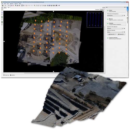
  • Create colorized dense point clouds, surface models and bare earth terrain models
  • Refine and edit terrain models
  • Create digital orthophotos, classic orthos as well as true orthos
Datasheet
Trimble Business Centre Photogrammetry
An Automated Processing Tool for your UAS

Trimble UX5 aerial image data can be processed into powerful deliverables with the Trimble Business Center (TBC) Aerial Photogrammetry module. The TBC Photogrammetry Module is based on state-of-the-art image processing technology. The incorporation of photogrammetric algorithms specialized for small UAS produces very accurate results automatically, with minimal manual interaction. This office software combined with the Trimble UX5 provides a reliable photogrammetric system delivering excellent results without requiring specialized photogrammetry knowledge or experience.

The TBC Aerial Photogrammetry module works seamlessly with the TBC Complete and Advanced software editions, making it possible to process complete survey projects including aerial imagery, Trimble VISION imagery, GNSS data, and total station observations.


Datasheet