
PRODUCTS
GEOPHYSICAL
SIDE SCAN SONAR
MAGNETOMETER
SUB-BOTTOM PROFILER
PIPE & CABLE DETECTION SYSTEMS
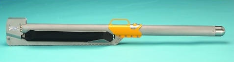
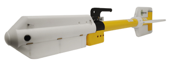
CMAX CM2 Digital Sidescan Sonar Standard
Standard SSS
C-MAX is a leading supplier of professional sidescan systems. The CM2 Sidescan Sonar System is noted for its performance and its robust, user-friendly design. The CM2 is supported by a complete range of accessories, including the portable winch, to aid the surveyor’s task.
CM2 digital sidescan sonar systems are in use all over the world in a wide variety of applications.
Features:
- High definition images
- Flexible system configurations
- Ease of use
- Robust build
- 3 year warranty
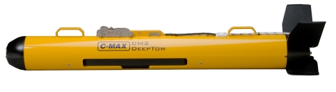
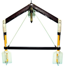
CMAX CM2 Digital Sidescan SonarDeeptow
Deeptow SSS
C-MAX is a leading supplier of professional sidescan systems. The CM2 Sidescan Sonar System is noted for its performance and its robust, user-friendly design. The CM2 is supported by a complete range of accessories, including the portable winch, to aid the surveyor’s task.
CM2 digital sidescan sonar systems are in use all over the world in a wide variety of applications.
Features:
- High definition images
- Flexible system configurations
- Ease of use
- Robust build
- 3 year warranty
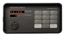
Geometrics G856 Magnetometer
Land Magnetometer
The G-856 provides a reliable, low cost solution for a variety of magnetic search and mapping applications. Single key stroke operation means the G-856AX can be operated by non-technical field personnel or used in teaching environments. The G-856AX uses the well proven proton precession technology, allowing accurate measurements to be made with virtually no dependence upon variables such as sensor orientation, temperature, or location. The unit provides a repeatable absolute total field magnetic reading, traceable to the National Bureau of Standards.
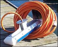
Geometrics G-882
Marine Magnometer
The model G-882 cesium-vapor marine magnetometer provides the same high performance as our airborne instruments delivering high resolution results in all types of survey applications. The G-882 is a low cost, compact system designed for professional surveys in shallow or deep water.
The G-882 magnetometer’s digital output can be recorded with any serial data logger but its full potential is obtained when used with our MagLog Lite™ software to log, display and print GPS positioned measurement results. The price, performance and reliability of the G–882 make it the best value of any marine
Geometrics G-882TVG
Cesium Magnetometer
Geometrics offers complete turnkey systems including tow cables, gradiometer wing, digital data
acquisition systems with real time anomaly detection, GPS navigation and post acquisition data
processing software and training. swiss replcia watches
The Geometrics Model G-882TVG Transverse
Gradiometer system mates the well- proven high-
performance cesium sensor with dual high
sensitivity and high speed CM-221 Larmor
Counters. This advanced integrated
magnetometer system provides unmatched
versatility in performance, with a wide sensor
separation for maximum target detection efficiency
and survey cost effectiveness.
The system comprises a transverse wing and two
G-882 Cesium Vapor magnetometer fish with
stabilizer weights and fins. Tow cables may be up
to 150m in length with standard power supply or
up to 700m with a high capacity voltage sense
supply. Depth sensors provide gradiometer
attitude and depth information to the operator
depth and an echo-sounder altimeter provides
height above sea floor for proper system flight
control.
Innomar SES-2000 Series
Smallest & lightest Sub-bottom Profiler
For Innomar's shallow-water sub-bottom profilers (SES-2000 compact, light, standard) there is a sidescan extension available.
This option can be used in applications that require not only sub-bottom data but also to determine seabed morphology and/or objects on the seabed. Applications include surveys in the dredging industry (looking for outcrops), archaeological surveys, pipeline tracking and presurveys of construction sites.
Models available:
- SES-2000
- 2000 AUV / ROV
- 2000 Compact
- 2000 Deep 15
- 2000 Deep 36
- 2000 Light
- 2000 LightPlus
- 2000 Medium-70
- 2000 Medium-100
- 2000 Quattro
- 2000 Standard
- 2000 Standard Plus