

PRODUCTS
LAND SURVEY
GNSS SYSTEMS
SCANNING & MAPPING
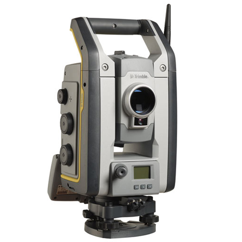
Trimble S7
The most productive Total Station
Features
- Surveying, imaging and 3D scanning in one powerful solution
- Improved Trimble VISION technology for video robotic control, scene documentation and photogrametric measurements
- Trimble DR Plus for long range and superior accuracy
- Locate2Protect real-time equipment monitoring and Trimble InSphere equipment management
- Complete field-to-office solution for quick data capture and processing
- Seamless integration with the Trimble V10 Imaging Rover and GNSS receivers
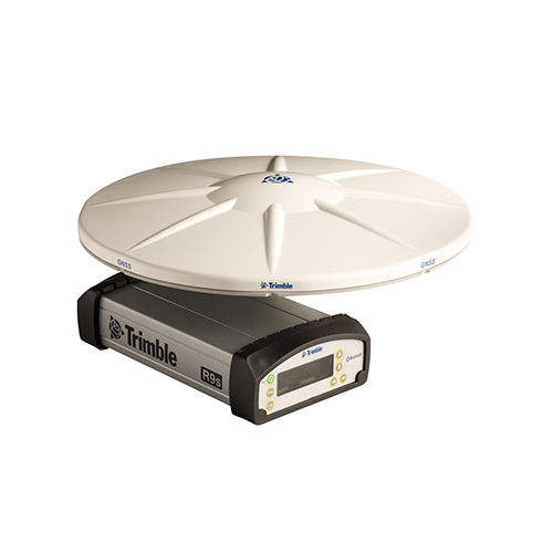
Trimble R9s
Scalable GNSS Modularity
- Advanced satellite tracking with Trimble 360 receiver technology
- Convenient front panel display and configuration
- Bluetooth®, Ethernet, serial and USB support
- Data logging internally and to external drive
- Multiple data file formats
- Trimble CenterPoint RTX provides RTK level precision anywhere without the need for a base station or VRS network
- Trimble xFill technology provides seamless RTK coverage during connection outages

Opera Duo
First Class Underground Survey
Main features include:
- Superior Maneuverability – A large, comfortable handle to make pushing and pulling easier, large wheels for better control and a balanced weight distribution to offer minimum resistance.
- Robustness – Engineered and built to withstand the harshest field conditions, the Opera Duo is suitable for heavy use in every type of terrain.
- Data Quality – Large bandwidth offering the highest resolution; the largest dynamic range for the best penetration depth; and dual-head sensor integrating ultra-wide band antennas (250MHz and 700MHz).
- Intuitiveness – Just click the start button to receive the best performance in every soil condition. No need to perform calibration or adjust any other manual settings.
- Results Delivered On Site – The system tracks the position of the radar and marks targets automatically. All of the acquired data can be exported to CAD and GIS, and reports can be produced directly on site.

RIS One & RIS Plus
Compact and lightweight ground penetrating radar
- Excellent data quality
- Highest flexibility in multi-channel chain connection
- High stacking thereby improving penetration depth
- Wireless link to keep track of the survey path and the location of buried objects;
RIS ONE and RIS PLUS are the ideal solutions for:
- Underground tunnel inspection and condition assessment;
- Bedrock and lithological profiling;
- Fracture characterisation;
- Ground water profiling;
- Foundation and pile measurements;
- Borehole investigations.
Trimble GEDO Track
Slab Track Construction
KEY BENEFITS
- Reduce construction time and costs with immediate comparison of measured data to design
- Verify track geometry with accuracy and confidence. Precise optical positioning and a simple, self-contained trolley provide flexibility and reliable results
- Capture track 3D coordinates, gauge and cant in a single operation
- Import alignment design from digital or paper plans. Check design information before it goes to the job site
- Reduce time for documentation and acceptance. Capture adjustment and track acceptance data and quickly prepare reports for contractors and quality inspection
- Support for industry standard calculations including FAKOP® widening
- Satisfy reporting requirements with graphical and list form output of corrections for side and height correction plates

Trimble GEDO Scan
Clearance Check & Scanning
KEY BENEFITS
- Simple, self-contained trolley used for Trimble GEDO Scan and other track measuring applications
- Helical scanning mode captures ceilings and walls to produce accurate 3D models of tunnels and overpasses
- Trimble GEDO Scan Field software runs on the Trimble Tablet rugged PC controller. The software controls scanning operations and data collection from the scanner and trolley
- Modular system lets you use the Trimble TX5 scanner for other survey and facility needs
- Workflow and user interface are consistent with other Trimble GEDO systems to reduce training and increase system productivity
- Supports 45° Mode for better object visibility at as-built scans